HOPI TUTSKWA – HOPI LANDS
“To Protect, Preserve and Enhance the Natural Resources & Environment of the Hopi people”
The Hopi Sinom and our ancestors, Hisat Sinom, have ancient ties to aboriginal lands occupied for over 2,000 years of cultural endurance.
Hopi Tutskwa (Aboriginal Hopi Lands)…Over 15 Million Acre Region (Prior to Spanish, Navajo & Mormon arrivals from 1540 to 1882 A.D.) 1882 U.S. Executive Order-Hopi Indian Reservation…..2.4 Million Acres
 2014 Hopi Tribal Land Base
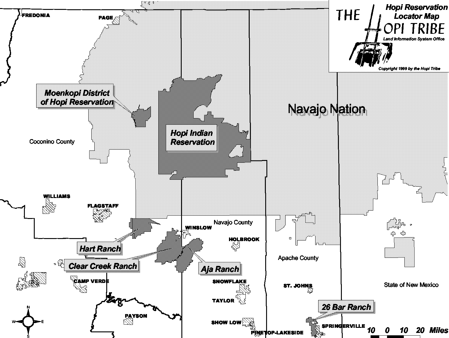
Hopi Main Reservation……………1,625,686 Acres
(District Six & Hopi Partitioned Lands restored to Hopi Tribe in 1974)
Moenkopi District Reservation…………61,604 Acres (Restored to Hopi Tribe in 1996)
Hopi Three Canyon Ranch Lands………175,441 Acres (Hopi Indian Trust Lands 2010 Managed by Dept. of Natural Resources)
Hopi Tribal Enrollment: 14,041 Members of 12 Villages (As of September 2014)
Main Reservation Climate: Annual precipitation is almost equally divided between summer monsoons and winter snow storms. The freeze-free period is between 130-180 days. Annual precipitation is from 5 inches in the southern lower elevations to 15 inches in the higher northern Pinyon-Juniper woodland areas atop Black Mesa plateau.
Vegetation & Elevations: Semi-desert Grasslands-Under 5,000 ft. with 5-8 inches of annual precipitation Mixed Grasslands-From 5,000 to 6,200 ft. with 8-12 inches of annual precipitation Sagebrush Grasslands-From 6,200 to 7,000ft., with 12-15 inches of annual precipitation Pinyon-Juniper Woodland-From 6,500 to 7,500 ft. with 15-17 inches of annual precipitaion.
Natural Resources: Quarried Sandstone, Fuel Wood, Rangeland, Coal, Sand & Gravel, Natural Springs & Reservoirs and Wildlife (Big & Small Game Hunting)
Agricultural Production: Hopi Dry Land Farming along with natural spring water irrigated fields in the Moenkopi Villages of various Hopi crops (corn, squash, beans, melons, etc.) and other vegetables & fruit trees. Range units support Hopi stockmen who raise grass-fed sheep and beef cattle with cow/calf operations.
Tribal Economy: Traditional Hopi Subsistence Agriculture, Gathering & Hunting, Hopi Arts & Crafts, Tourism, Beef Cattle, Tribal and Federal Government & Local Small Businesses
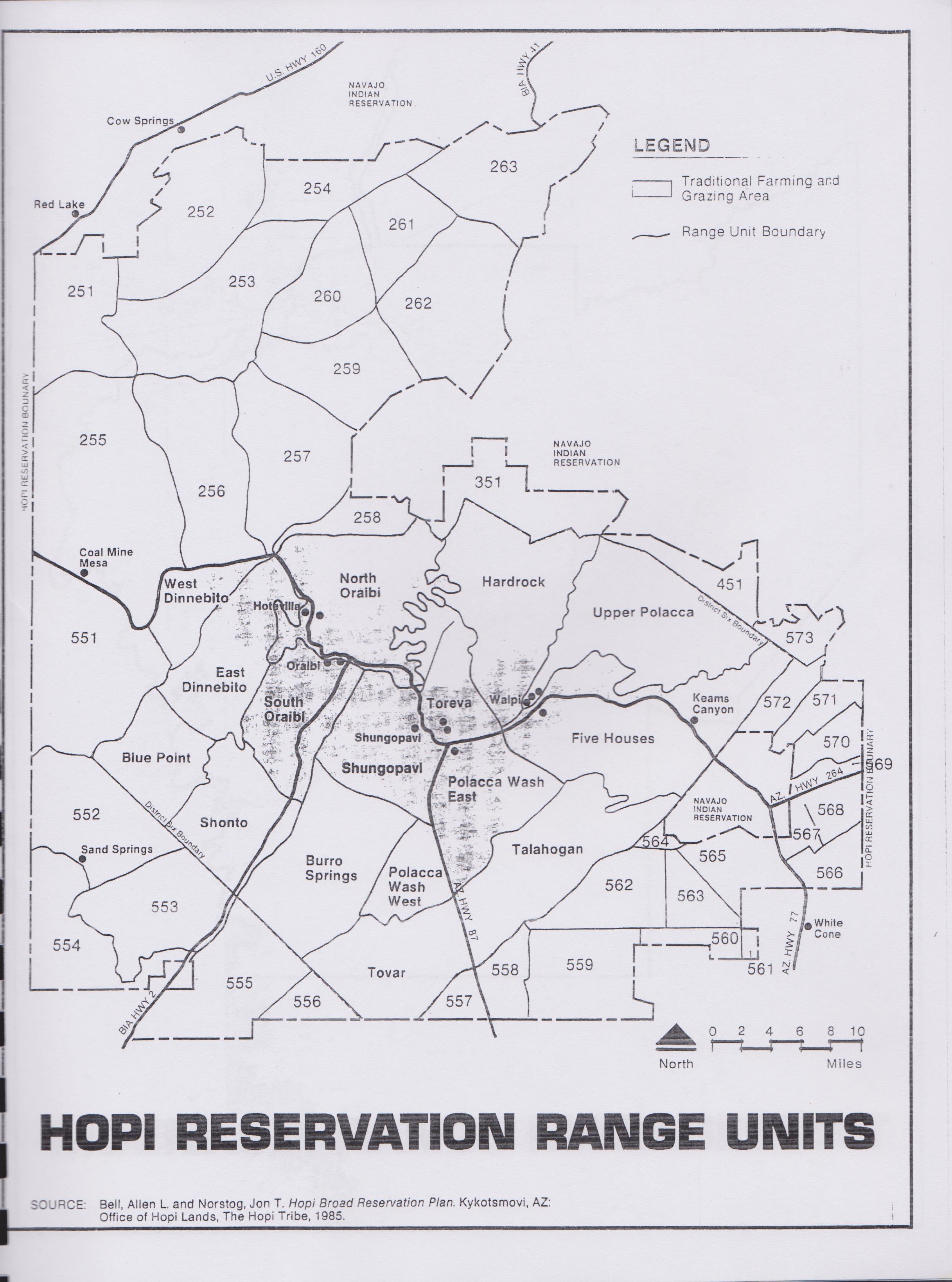 Hopi Reservation Range Units
District Six Management Area: Blue Point, West* & East*Dinnebito, North* & South* Oraibi, Toreva*, Hardrock, Upper Polacca, Five Houses*, Talahogan, Polacca Wash East* & West, Tovar, Burro Springs, Shungopavi & Shonto.
*Units with Traditional Farming & Sheep Grazing Areas
Hopi Partitioned Lands Range Unit #’s: 251, 252, 253, 254, 255, 256, 257, 258, 259, 260, 261, 262, 263, 351, 451, 551, 552, 553, 554, 555, 556, 557, 558, 559, 560 (merged with former 561), 562, 563, 564, 565, 566, 567, 568, 570 (merged with former 569), 571, 572 & 573
Tribal & Department of Natural Resources Plans, Policies & Ordinances:
♦ Hopi Integrated Resources Management Plan (Adopted May 2001)
♦ Hopi Tunatya’at 2000-Hopi Strategic Land Use & Development Plan
♦ Hopi Pötskwani’at 2011—Hopi Tribal Consolidated Strategic Plan
♦ Hopi Integrated Woodlands Management Plan (Adopted 2006)
♦ Hopi-BIA Wild Land Fire Management Plan (Adopted 2006)
♦ Hopi-FEMA Natural Hazard Mitigation Plan (Approved 2006)
♦ Hopi Drought Contingency Plan (Adopted August 2000)
♦ Hopi Tribal NEPA Compliance Process (Adopted 2001)
• Ordinance#26 Hopi Cultural Preservation Code
• Ordinance#43 Control of Livestock and Grazing
• Ordinance#44 Solid Waste Management
• Ordinance#47 Woodlands
• Ordinance#48 Wildlife & Hunting/Furbearer Trapping Regulations
• Ordinance#53 Civil Trespass • Hopi Water Code: Water Quality, Well Construction & Wellhead Protection
* Federal Laws & Regulations applicable to Hopi Indian Trust Lands & Assets